A small Holy Grail find in TNA
Posted: 30 January 2010 13:24
My first visit to Kew in 2010 has turfed up an interesting document that gives an enormous list of defence works, including pillboxes, roadblocks and railblocks.
As usual, it's the unexpected finds that turn out to be the best and part of my current strategy is 'mopping up' a few files. This entails searching out the less obvious units and departments belonging to an infantry division, such as those involved with the logistics of petrol and ammunition supply.
I'm also having to go back to a lot of 55 Division files, as I only covered them up to the point at which they were relieved by the Canadians. What I didn't realise was that this relief only lasted about 6 weeks to allow 55 Div a chance to conduct training away from the frontline. 55 Div then came back to East Sussex for another two months, and it's this period I need to catch up on.
The Holy Grail I refer to was located in a 'mopping up' file of 1940 and is the defence scheme for 'E' Sub-Area, which covers the northern part of the Weald of East Sussex (pre 1974 boundary) and a small part of Kent. A very rough boundary would run from East Grinstead along the Kent/Sussex boundary to somewhere SW of Ashford, down to Robertsbridge and westwards to Uckfield.
This is the first document I've found to date that describes in detail the defence of this area which is to the rear of the coastal strip that attracts the most attention.
A key aspect for me is that it contains a long list of pillboxes on both the Corps Stop Line and the GHQ Line. In other regions of the UK I expect this sort of document is quite common, but I know of no other wartime list of these defence works for East Sussex.
The table below gives some basic statistics of listed works in the scheme; 'New' refers to works which were not previously in the Concrete Evidence database:
| Pillboxes | Roadblocks | Railblocks | Searchlights | Home Guard OPs | |||||||
|---|---|---|---|---|---|---|---|---|---|---|---|
| Listed | New | Listed | New | Listed | New | Listed | New | Listed | New | ||
| GHQ Line | 211 | 196 | 56 | 18 | 21 | 7 | 32 | 32 | 60 | 60 | |
| Corps Line | 52 | 49 | 26 | 2 | |||||||
| Total Listed | 263 | - | 82 | - | 21 | - | 32 | - | 60 | - | 458 |
| Total New | - | 245 | - | 20 | - | 7 | - | 32 | - | 60 | 364 |
From this we can see that of 458 features listed in the scheme, 364 were not already in Concrete Evidence. This is obviously fantastic for me as my eyes have been opened to various aspects and attitudes towards the defence of this rear area. Out of the 82 listed roadblocks, only 20 were unknown to me, which gives me a good idea of how comprehensive the Roadblock Report (another Holy Grail) was. These 20 blocks must have already been dismantled by the time of the report, which was just a year later; food for thought on the deprecation of stop lines.
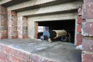
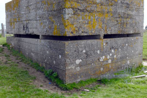
The photos below show a pillbox dug into a roadside bank at Jarvis Brook near Crowborough; I had always suspected that it covered a roadblock, but the Roadblock Report does not list one as being here. However, the earlier defence scheme confirms that there was indeed a block near this road junction.

The presence of seven previously unknown railblocks was a surprise and opens up a whole new can of worms beyond the 1941 Railblock survey. The searchlight and OP locations are an unexpected bonus, although a subsequent amendment to the scheme rules out further listing of the former, as their locations were changing too frequently.
Processing the data
One problem I had was reconciling the defence scheme list with Concrete Evidence, as some pillboxes (such as those at Old Lodge Warren) were already listed and with every chance that my grid references differed to those on the list.
It turns out that my references did differ, with some half a grid square out.
I faced the same problem as I did with cataloguing the data from the Roadblock Report; existing database records risked being duplicated unless I was very careful.
Had I not listed several GHQ Line pillboxes a few weeks back, there would not have been a problem, as the new data from the defence scheme could have been pasted wholesale into the database. Because of the risk of duplication, I had to work out which ones were already listed and this proved confusing simply because I had got my original grid references so disastrously wrong.

My solution was to draw up a grid to represent map squares and plot the pillboxes from the scheme and match their pattern from my knowledge of the layout from fieldwork.
The image at right shows the grid that was quickly knocked up in Word; it wasn't worth trying to make the boxes square.
I simply marked each grid 'square' in which a pillbox was listed and discovered the pattern matched the layout of those I had visited. I say 'simply', but I still made some errors as can be seen.
Having established which references belonged to which pillboxes, I could add data to the existing records rather than create new duplicate ones.
This is not the end of the difficult part though.
Correlating the data with DoB
The DoB did a pretty good job and have compiled the most comprehensive stop line pillbox list for East Sussex to date.
I had been dreading the day that I would eventually have to start trying to interpret their findings and enter each pillbox one at a time into my database with a map reference converted from National Grid to Cassini Grid. This would entail visiting the site to get a visual fix, and then try and plot the location on the old wartime map. It was this process that led me to produce the set of inaccurate locations mentioned above.
Thanks to this new list I have been spared the greater part of that task, now having a large bulk of pillboxes already recorded. This means that instead of having to visit hundreds of sites to compare the landscape to the DoB data, I now 'only' have to adjust the latter to match with the new data to identify gaps.
Of course, this is NOT a substitute to field visits and the wartime grid references may not be completely accurate, but what's important here is establishing the layout of the defences in relation to each other, much the same way as seen in the grid exercise above. Many of those pillboxes visited by DoB recorders include the serial numbers in the data; this information is not included in the defence scheme and this is why I need to integrate the two datasets.
The DoB recorded 25 pillboxes on the Corps Line, just under half the number listed in the defence scheme; this is a manageable amount to work with and will hopefully be a relatively simple task to process the data.
A rough search of DoB for 'pillbox' in 'Sussex, East' with defence grouping 'GHQ Line' returns 225 results, 14 more than listed by the defence scheme. Now consider that the latter only covers the northern end of the GHQ Line, while DoB lists about 70 pillboxes outside that of the scheme.
DoB therefore lists about 155 pillboxes in the area in which the defence scheme lists 211, leaving us with around 60 that are seemingly unaccounted for. This is all a pleasant surprise; I suspect that most (if not all) of the missing pillboxes will have been destroyed, but you never know...
- Pete

Email:
Blog Latest
Bishopstone reveals its pillbox secrets
18 October 2021
Pillbox or Observation Post?
10 June 2020
Uncovering the hidden secrets of a pillbox
8 June 2019
Review of 2018
31 December 2018

Wartime Christmas in East Sussex (2)
24 December 2018
Jargon-buster
Cassini Grid
Cassini Grid was the map reference system in use on British military maps from 1919 until the introduction of the National Grid Reference system still used today on Ordnance Survey maps. The two systems are not related, and so wartime Cassini references need to be converted to modern National Grid. More information can be found on the maps page.
Defence scheme
A military plan of defence for a specified area. Defence Schemes were issued at numerous levels. Defence Schemes were later known as Plans to Defeat Invasion on the orders of General Montgomery.
GHQ Line
A series of arterial stop lines designed to prevent German forces advancing on London and the industrial Midlands.
Pillbox
Generic term for a hardened field defensive structure usually constructed from concrete and/or masonry. Pillboxes were built in numerous types and variants depending on location and role.
Stop line
A physical continuous anti-tank barrier, normally a river and/or railway line, often defended by pillboxes. Stop line crossings (roads, railways and bridges) were to be made impassable.
TNA
The National Archives (formerly The Public Records Office or PRO).
This site is copyright © Peter Hibbs 2006 - 2026. All rights reserved.
Hibbs, Peter A small Holy Grail find in TNA (2026) Available at: http://www.pillbox.org.uk/blog/216651/ Accessed: 18 June 2026
The information on this website is intended solely to describe the ongoing research activity of The Defence of East Sussex Project; it is not comprehensive or properly presented. It is therefore NOT suitable as a basis for producing derivative works or surveys!