Did the Germans really destroy Martello Tower 63?
Posted: 30 October 2011 10:19
After 23 years of researching Martello Towers, I've finally got to the bottom of a mystery surrounding the loss of one near Pevensey and learned an important lesson in trusting what the documents say.

Firstly, the source of all this; in 1972 Martello Towers by Sheila Sutcliffe was published and it remained the definitive work for nearly 30 years.
It said the following of Tower 63:
During World War II, the martellos were very much in the front line, both geographically and because many of them were used for military purposes, and this tower was blown up by the enemy. (My emphasis).
Two years later, a pamphlet by local historian Harold Spears was published in Eastbourne. Local Martello Towers: some notes simply stated: "Tower 63: Demolished during the last war and the rubble was used at the RAF Airfield at Friston."
Two other versions of the tower's demise have come to my attention since my own Martello research began in 1988, namely that the tower was "blown up by the Royal Engineers in 1942" and the possibility that it was removed to clear the field of fire for the Emergency Coast Defence Battery to the west at Pevensey Bay.
We can immediately rule out the latter point as the Fort Record Book for the battery indicates that for beach targets, the eastern arc of fire was 208°. Tower 63 was further inland on a bearing of 215° from the battery. Had the tower been removed for this reason, the arc would have at least been equal to 215°.
What about Sutcliffe's mention of enemy involvement? Throughout my research of Martello Towers I've found no evidence of enemy attack and I can only guess that, presented with the story that the tower was blown up, she presumed that only the enemy would have been responsible. Life's too short for me go into the forensic analysis I conducted of Luftwaffe dive-bombers, bomb weights, bomb casing thicknesses and penetration of masonry.
Moving from my Martello work and into DESPro, I've constantly been on the lookout for any scrap of evidence. Regular visitors to this site will know how much I tend to cling on to such scraps and end up coming to some sort of conclusion. I constantly bang on ad nauseum about how the documents will tell you what was going on, but always with the proviso (and this goes for any historical source) that they may be inaccurate or incomplete.
The lesson I learned was to stick to my own advice; as I shall explain below, even though I was finding scraps of information, I was systematically ignoring them - and on what I mistakingly believed to be good reasons.
Was Tower 63 destroyed before the war?

My long-standing theory was that the tower was demolished by civil engineers by 1939.
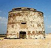
The photograph shows the tower as it was in about 1937-38; the sea lies beyond the buildings on the horizon.
The activity going on here is shingle extraction. The shingle was dug out, graded and sold for use in construction, but by 1937-38 the local press was running stories on how the locals were fearful that the extraction pits (which can be seen here) were flooding.
This brought about the risk that the shingle bank between the pits and the sea might be weakened, with the possibility that the sea would break through.

My assumption has always been that the tower was demolished in order to provide material to help backfill a gravel extraction pit and/or in connection with housing development.
The photo at left is partly what this idea was based on. The exact date is unknown, but we have what appears to be a large circular pit with a mechanical excavator in it.
The building is that seen behind the excavator in the photo above and so the pit appears to tie in with where you expect the tower to have been.
We have some dating evidence in the form of a local resident who remembered that the garden wall seen here was removed in 1939. We therefore appear to have evidence that the tower had gone by 1939 - there's certainly no 1940 beach defences evident.
We also know that the area had been bought and property development was proposed; a derelict tower was a nuisance and the developer concerned had demolished at least two other towers previously.
The WW2 documents
This all seems to add up nicely, but once I began researching the WW2 defences, a small problem kept cropping up; the documents seemingly vaguely hinted that the tower still stood after my theory said it should have been demolished.

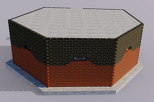
Now, when you've studied Martello Towers for 20 years you learn that, to the casual observer, one tower looks pretty much like any other and confusion over which is which is rife; the graphic at left demonstrates the plethora of towers.
Tower 65 is shown in its ruinous state in 1935, while Tower 62 is shown with its prewar glazed roof. Tower 60 is seen without a wartime roof.
German evidence that the tower stood beyond 1939
German intelligence material counts eight towers between Eastbourne and Hastings. I didn't rely on this as a reliable indicator that 63 still stood as not only was German intelligence often based on pre-war information, but they sometimes class Tower 73 at Eastbourne under it's popular name, "Wish Tower" (Wish-Turm) and not as a Martello per se. Then throw in the fact that Tower 65 was only lost in 1934-35 and you have mounting confusion over numbers - did the Germans account for Tower 65's loss, and that of Tower 67 (washed away c1922)?
The 1940 Befestigungskarte marks Tower 63 on the map, but again, this is based on a prewar map. The accompanying aerial photograph frustratingly cuts off the coastal area. Another German AP from 1940 is too small to distinguish individual towers.
Allied evidence
The first British documents I had that the tower might have survived beyond 1939 was a 1943 document from the Fort Record Book of the Wish Tower Battery at Eastbourne; they specifically have a Martello Tower with the grid reference to match that of Tower 63 regsistered as a target for landward firing. I simply disregarded it as the wrong tower; this was one of the first files I consulted and I was not yet confident with the Cassini Grid reference system. Older and wiser, I now know that artillery grids are pretty reliable for obvious reasons. Would they really have got the wrong tower?
But I know of only four towers occupied by the army from 1940 and that were modified with the addition of a concrete roof; 66, 64, 61 and 55. In 1940 four towers were known as A, B, C and D and these match the above towers.
However, Tower 62 also has a concrete roof, and although it lacks the embrasures of those added to the other towers, pre-war photos show Tower 62 sporting a glazed roof of the type seen on modern tower conversions. Tower 60 did not have a roof added, and it's not certain that it ever was occupied by the army.
A British 1941 defence scheme map-trace of the area marks Tower 63 and places a Bren gun at that location, but offers no clue as to whether the tower actually still stood. Again, I assumed the trace was based on an old map and confusion over which tower was which caused an error.
The problem with all of these forms of 'proof' is that they were all potentially based on prewar maps and so conclusive evidence was not strong enough for my liking; I therefore disregarded it all.
The indisputable evidence
A visit to the National Archives in January 2011 delivered an enormous research bombshell with a terse one-line entry in a war diary:
Demolition of Martello Tower at Pevensey carried out.
This was a hard-hitting lesson; convinced that the mounting (yet still circumstantial) evidence from the documents was caused by successive people (who were there at the time) on both sides getting it wrong, I'd failed to see that it was actually me getting it wrong every time by dismissing each piece of evidence.
In my defence, the date upon which Tower 63 was demolished was a complete surprise; one would assume that had enemy action destroyed the tower, it might have occurred 1940-42. A similar period might reasonably be applied to destruction by the Royal Engineers, who were the actual culprits. Was it the dark, desperate days of 1940? Was it perhaps true that the rubble was used at Friston Airfield (built 1940-41) as was suggested above?
The date of the diary entry was 1944.
This was a shock; why so late in the war? The only reason I can offer at this point is the need for hardcore for construction of installations for the D-Day build-up. As stated above, the developer who owned the land and Tower 63 had previously demolished at least two other towers and would have probably been only too pleased to have the RE do the job for them.

Surviving evidence
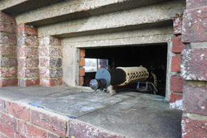
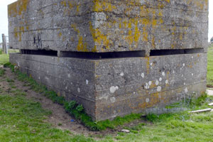
In 1998, I discovered the block of masonry in the photograph at right a couple of hundred yards away from where Tower 63 once stood; it would have subsequently been removed during the construction of the Sovereign Harbour development that was underway at that time.
Its composition was undeniably of Martello design and proportions; where the rest of the rubble went is unknown. I had previously speculated on the Martello Tower website that (assuming a demolition date of c.1942) it might have been used as hardcore for the tank roads on the Downs.
However, these roads were completed two years before the tower went and the Operational Record Book for Friston Airfield makes no mention of any construction work going on in 1944.
Some mathematical calculations based on data I've found in the National Archives dated 1807 reveals why a Martello Tower would be a good source of hardcore. A list of estimates of the masonry mass in each tower (for purposes of settling the bill) lists how many cubic feet of masonry comprised Tower 63.
Using this data and comparing the tonnage of hardcore listed in a 1942 engineer's war diary for a particular stretch of tank road, I've done a few calculations. By my reckoning, Tower 63 contained enough masonry to produce sufficient hardcore for a stretch of road 8 yards wide and a staggering 10 (ten) miles long!
I performed the calculations twice using different methods and had them independently verified and they seem to be correct. It seems a high figure, even for a rough military road of dubious quality, but every construction project probably depended on local conditions. There is no evidence that the tower was specifically used in a road; this is just an example.
What of the photograph above showing the excavator in what I assumed was the foundation pit of the tower? The only explanation is that the tower must be out of shot to the left.
The main thing is that the mystery of Tower 63 has been solved and I've learned a valuable lesson; when multiple documents are telling you the same thing, they may just be telling the truth!
- Pete

Email:
Blog Latest
Bishopstone reveals its pillbox secrets
18 October 2021
Pillbox or Observation Post?
10 June 2020
Uncovering the hidden secrets of a pillbox
8 June 2019
Review of 2018
31 December 2018

Wartime Christmas in East Sussex (2)
24 December 2018
Jargon-buster
Befestigungskarte
Fortifications map compiled by German Intelligence from aerial photographs during 1940-41 in preparation for Operation Sealion. Defence works were plotted using a system of red symbols.
Cassini Grid
Cassini Grid was the map reference system in use on British military maps from 1919 until the introduction of the National Grid Reference system still used today on Ordnance Survey maps. The two systems are not related, and so wartime Cassini references need to be converted to modern National Grid. More information can be found on the maps page.
Defence scheme
A military plan of defence for a specified area. Defence Schemes were issued at numerous levels. Defence Schemes were later known as Plans to Defeat Invasion on the orders of General Montgomery.
Demolition
Term applied to a structure scheduled for demolition or already demolished. Walls and small buildings might be taken down to clear fields of fire or impede enemy passage by destroying a bridge. Some demolitions were not intended to be carried out until after invasion had begun, for example, certain bridges or road craters (pipe mines).
DESPro
The Defence of East Sussex Project.
Embrasure
A loophole or slit that permits observation and/or weapons to be fired through a wall or similar solid construction.
Emergency Coast Defence battery
As the name suggests, a battery established during wartime for coast defence to augment batteries established in peacetime. Emergency batteries established during 1940-41 usually employed a pair of old naval guns, usually either of 6-inch, 5.5-inch or 4-inch calibre.
Martello Tower
Napoleonic gun towers built along the vulnerable coasts of SE England 1805-1812. Most that still stood in 1940 were occupied for military defence, as artillery observation posts or by the Royal Observer Corps. Many towers had a concrete roof added for extra protection.
War diary
A record of events kept by all units from the point of mobilisation. A diary's contents vary enormously from unit to unit; some give detailed entries by the hour on a daily basis while others merely summarise events on a weekly/monthly basis.
This site is copyright © Peter Hibbs 2006 - 2026. All rights reserved.
Hibbs, Peter Did the Germans really destroy Martello Tower 63? (2026) Available at: http://www.pillbox.org.uk/blog/216690/ Accessed: 26 June 2026
The information on this website is intended solely to describe the ongoing research activity of The Defence of East Sussex Project; it is not comprehensive or properly presented. It is therefore NOT suitable as a basis for producing derivative works or surveys!