Now We Are Six
Posted: 13 March 2012 21:52
10 March 2012 marked the sixth anniversary of the Defence of East Sussex Project; today signals the point at which my research has lasted longer than World War Two itself!
Looking back, it appears that I only managed to post a measly 10 blog entries since the Project's fifth birthday one year ago. I touted the year to that date as "the best year so far", but the year just gone could also have claimed to have been as successful, in many ways. Hopefully, the account below will demonstrate that I'm still working my socks off, at the expense of keeping you all informed!
The South Coast Martello Towers website

Firstly, the bad news. I took the sad decision to remove my popular Martello Towers website in late 2011. It had been online since 1998 and it was a product of that time, in that the spirit of the Internet was very different in those days. Back then, I had no qualms about posting all of my research online as a resource freely available to all.
However, this honeymoon wasn't to last, and over the years I saw a lot of plagiarism of all of my websites, which is why you see so many copyright notices all over this website.
I was starting to see my images and text appearing on other websites, in various talks I attended and in publications. As people were making money from my research, seeing Martello Tower documents and plans copied from The National Archives (TNA) being posted online in a forum was the last straw, as it would only be a matter of time before somebody took chunks of my research and married it up with archive documents ripped off the Internet and published it.
As I couldn't find the time to look after the site and continue to police the Internet for copycat sites, I felt I was ready to call time on the project. So unfortunately, the wealth of information I had researched and posted was the very undoing of the site - some Martello Towers are included in Concrete Evidence though. 18 months ago I had four large websites online; I now just maintain this one...
Rant over - let's get back to the positive stuff!
Getting dirty
The past year has seen me getting further involved in the archaeological side of things despite my having no archaeological qualifications.

Having been a member of Sussex Military History Society for a few years now has certainly brought me into contact with like-minded people and has opened up some very interesting holes under my feet!
Various site survey reports are in the course of writing and so I can't reveal any details of locations for the time being, by agreement with the various landowners who kindly gave us permission to excavate.
Suffice it to say that we've dug big holes (right) to get down deep as well as some small ones that just scratch the surface.
The results of the SMHS team's efforts have been outstanding - watch this space and http://www.sussexmilitary.org.uk/ for project reports!

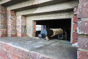
The photo at left shows a small trench we sunk to locate the foundation slab of a structure we were surveying in order to expand the local Historic Environment Record (HER).
The discovery of a pair of communications cables was an unexpected bonus - although they were marked on wiring plans I had previously found in the archives, we hadn't expected to find them lying on the foundations just a few inches below the surface.
The study of 22-core armoured cable is seemingly a very obscure subject, but tying the documentary evidence in with the landscape is essential in understanding what you find when you open trenches like this, not to mention highly satisfying!
Documentary Research
The past year has seen me visit TNA on eleven occasions, drawing 267 files. This brings me to a total of 60 visits in the past six years, having drawn a total of 980 files in my search for East Sussex material. Another visit should see me top 1,000 files, with possibly another 1,000+ still to view.
Does this mean it'll take me another six years to go through all the files? Quite possibly, as I've shifted the project's goalposts!
Mission Creep
It was inevitable, but the Defence of East Sussex Project scope has broadened due to the wealth of archive material being located.
I keep doing this; when I first started back in 2006 my intention was just to add any surviving WW2 defence works to my fledgling Concrete Evidence database, from Kent, Surrey, Sussex and London.
I then began research at TNA, and attempted to narrow things down to the 1940 anti-invasion defences of Eastbourne.
This was blown out of the water by my not finding any substantial documents regarding Eastbourne (and I still haven't today), but as I did find some detailed plans for Newhaven, I started to research there instead.

However, my interest broadened again with the documents telling me where things were, and so I expanded to cover the 45 Division Area of Kent and East Sussex, leading me along the Royal Military Canal and its Type 22 pillboxes (photo right).
Again, I found taking on Kent was too much of a burden, and so I settled upon the 1940 anti-invasion defences of East Sussex alone. Then I crept into 1941 - I was intending to stop here as the Canadians began their tenure of the area, and I wasn't intending to travel to Canada to access war diaries there. I then realised that copies of the Canadian files were at Kew and so began a new chapter.
The situation as of today (actually about six months ago, as I'm behind with everything as usual) is that I'm now covering the entire war in East Sussex, from the mobilisation of the local Territorial Army units in 1939, to the cleaning-up operation and return to peacetime activities.
This expansion has come about for several reasons. Firstly, because the documents survive; the Army List for 1939 tells us which TA units were where, allowing me to follow their paper trail from 1939.
Secondly, and most importantly of all, knowing what's going on both before and after the invasion scare helps me to fully appreciate the archaeology in the landscape.
The 'invasion' landscape may be post-invasion

There have been at least two areas in which knowledge of what happened later on has helped interpret the landscape.
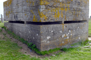
The first case was on the Downs, where I found an odd set of slit trenches set away from the main defended locality established in 1941.
I wrote them off as outposts on a flank, although I couldn't explain other unusual lumps and bumps nearby (photo, right). Having read further on in the documents, a 25-pounder field gun was dug in at this location in 1943, explaining why these features didn't make sense in the earlier layout. The photo shows what might be a gun pit.
Another case was a coastal locality where slit trenches were documented in 1940. Again, the landscape didn't really fit with this description. Whilst doing some micro-research for an interpretation panel, I discovered that the reason the landscape didn't seem to be pockmarked with slit trenches is that an anti-aircraft battery was sited there during the V1 campaign of 1944, seemingly obliterating the earlier earthworks.
This is now another of my mantras - in order to study the anti-invasion archaeology of 1940-42, you need to know what happened after this period. So much went on after 1942 in terms of the build-up to Operation Overlord and Operation Diver that you need to know what went on and where in order to interpret the landscape and identify the different phases of earthworks.

New project scope
So, the new project parameters notably includes the following:
1. The Phoney War September 1939-May 1940
2. Army camps (right)
3. Overlord preparations (marshalling, landing craft hards, petrol/ammunition dumps, communications)
4. Anti-aircraft defences (1939-45) including Overlord defences and Diver guns
The question you'll be asking is: is it realistic for me to attempt all of this extra research?
My response to the above question would be yes!
Database development
My confidence in taking on this extra workload comes from the databases that form the central core of the project. A database system that holds information on several thousand sites/features from 1940-42 is just as capable of containing thousands more from 1939 and 1943-45.
The stats as they stand are as follows: 3369 sites with 3505 functions, making a total of 3878 features. (In fact, my writing this post is delaying the entry into the database of 200+ anti-aircraft gun positions...).
A new feature I'm developing into Concrete Evidence comes as a result of the expansion into anti-aircraft guns. A lot detailed documents exist relating to engagements, so I'm able to start cataloguing these and associating 'kills' with individual gun batteries and units.
All of this data is now throwing up its own problems, particularly means of keeping on top of it all. I'm now at the stage where I'm developing diagnostic tools to manage databases and I've now found it expedient to put details of every document photo into a database in order to keep tabs on it all. The result of this is that the database can now locate an individual image and tell me what information is on it.
A book?
The question that everyone is now asking me (or, to be more precise, the thing that everybody is now telling me) is that I should write a book.
This has been part of my plan for some years, but I've always been too busy in the actual research to have made significant headway into this. Constantly expanding the project scope doesn't really help in this regard... However, once I've researched the Phoney War period in more depth, I should be ready to write the first in a series of books that'll take you from the last days of peace in 1939 through the most tumultuous period of modern history.
I've already sketched out a series plan that works chronologically (and by location where necessary) to describe local events, defences and strategy within the context of world events. My current estimation is that I have enough historical material to write about thirteen books - which is why I want to get writing as soon as possible!

The landscape reveals more
Although I decided to extend my research beyond anti-invasion defences, the 1940-41 landscape is still adding to my workload.
The invasion landscape is still revealing hidden secrets; my previous blog post (three long months ago) described a pillbox sinking into a dune at Camber Sands.
A recent return visit to Camber demonstrated how the (literally) shifting sands of time can start to bring evidence back to the surface. The photo at right is of the roof of a submerged pillbox that has begun to be revealed.
From the look of the chamfered roof that has begun to emerge from the sand, this pillbox would appear to be of a similar design to the one previously described.

This pillbox has already been documented and is included in the Historic Environment Record, but it seems that this is the first time in nearly a decade that it has put in an appearance. It wouldn't surprise me if it disappeared again tomorrow given the nature of the drifting sands.
Pillboxes are not the only concrete that has floated to the surface in recent weeks; only yesterday I spotted an isolated cube on my way through a Wealden town.
This particular example is on a building site in a nodal point that had a dragon's teeth perimeter and numerous roadblocks.
Perhaps the most unusual manner in which new evidence came to light involved a group of 29 pimples - for sale on an internet auction site!

I took a trip out to visit the seller and try and ascertain the story behind them. It turns out that they came from Rye, and had been uprooted several decades ago and dumped in a pond. The seller then came by them after being contracted to remove them whilst dredging the pond!
Perhaps you can see why I keep extending the scope of my research - with all the evidence that has been coming to light it's clear that the story is still going on after 70 years!
- Pete

Email:
Blog Latest
Bishopstone reveals its pillbox secrets
18 October 2021
Pillbox or Observation Post?
10 June 2020
Uncovering the hidden secrets of a pillbox
8 June 2019
Review of 2018
31 December 2018

Wartime Christmas in East Sussex (2)
24 December 2018
Jargon-buster
Defended locality
An area defended by a force (e.g. a platoon) occupying a series of defence works, normally within a barbed wire perimeter. Localities were designed for all-round defence and usually fitted in with a coordinated scheme of neighbouring localities.
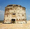
Martello Tower
Napoleonic gun towers built along the vulnerable coasts of SE England 1805-1812. Most that still stood in 1940 were occupied for military defence, as artillery observation posts or by the Royal Observer Corps. Many towers had a concrete roof added for extra protection.
Nodal Point
Defended road junction(s), usually within a village/town with a Home Guard garrison intended to deny enemy use of the roads. Nodal Points were not to defend the village, but solely the road network. Category 'A' Nodal Points were to hold out for 7 days after invasion without outside assistance.
Operation Diver
The plan to defend the UK against the German V1 Flying Bomb, which was codenamed Diver. Diver defences comprised barrage balloons and anti-aircraft guns, initially situated in the Kentish Gun Belt. The guns were later moved to the coast. Aircraft were coordinated with both phases of gun belt defence.
Operation Overlord
The codename for the Allied invasion of occupied Europe on 6th June 1944.
Pillbox
Generic term for a hardened field defensive structure usually constructed from concrete and/or masonry. Pillboxes were built in numerous types and variants depending on location and role.

Pimples
Small anti-tank block in the form of a truncated pyramid. Pimples were used to extend anti-tank obstacles and roadblocks and were intended for use on soft ground.
Slit trench
Small, narrow trench designed to provide protection against shrapnel and other battlefield hazards. Technically distinct from a weapon pit (which was intended soley as a defensive position) slit trenches were also used as defence works.
SMHS
Sussex Military History Society
TNA
The National Archives (formerly The Public Records Office or PRO).

Type 22 pillbox
A small hexagonal pillbox for six men not commonly seen in East Sussex, though a few still survive along the Royal Military Canal stop line.
This site is copyright © Peter Hibbs 2006 - 2026. All rights reserved.
Hibbs, Peter Now We Are Six (2026) Available at: http://www.pillbox.org.uk/blog/216693/ Accessed: 26 June 2026
The information on this website is intended solely to describe the ongoing research activity of The Defence of East Sussex Project; it is not comprehensive or properly presented. It is therefore NOT suitable as a basis for producing derivative works or surveys!