Your Britain - Fight for it Now
Posted: 7 August 2013 18:05
The iconic poster of the South Downs designed by Frank Newbould in 1942 has fascinated me for many years; close inspection reveals some interesting details.
I briefly mentioned this poster in part 2 of my East Sussex wartime writers and artists series, but I decided to cover this artwork out of the series in order to do a more detailed piece on it.
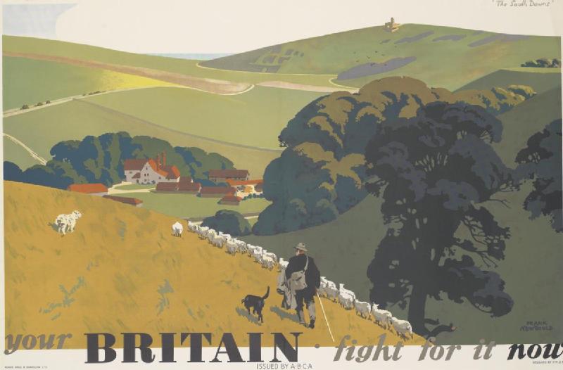 Your Britain - Fight for it Now South Downs (C) IWM (Art.IWM PST 14887)
A framed facsimile of this poster has hung in my house for nearly thirty years, and, although I've been meaning to do it ever since I knocked the picture hook into the wall, I've never attempted to locate the artist's original viewpoint in the landscape.
That is, until now! Once had I decided to compile the writers and artists series, I realised that it was finally time to get out and take a comparison photo.
I thought it would be a simple task, bearing in mind the obvious landmark of the Belle Tout lighthouse on the horizon.
I consulted maps and Google Earth in order to locate the valley that runs from bottom right of the painting. The graphic below shows the valley that I felt would be the best fit.

Having arrived at the valley, I fully expected the buildings in Newbould's work to have been artistic licence, perhaps based on a barn or other structure in the landscape.
The photo below shows my first attempt to recreate the view.

Even though the relationship between the valley and Belle Tout vaguely works, I wasn't convinced. I carried on walking around to see if turning the corner at the end of the valley would suddenly reveal the view I was looking for.
The valley proved not be open-ended, and so I trudged over the top - and suddenly found myself with the view in the photo below!

As can be seen, it wasn't the farm buildings that were artistic licence - it was in fact the rolling downland on which the shepherd and sheep are wandering!
The view of the landscape
Visiting the site, you really appreciate why Newbould chose it as a quintessentially 'British' landscape; the panorama below gives you the wider view.

I personally found it quite an amazing experience being here on a very sunny Saturday afternoon and I spent two hours just taking it all in.

Aside from the presence of modern vehicles and farm buildings, everything is pretty much as Newbould might have seen it.
A game of cricket being played on the recreation ground near East Dean, the bleating of sheep, honking of geese and the distant stutter of a tractor as it moves along the edge of a cornfield in crop.
For me, the only thing missing from this stereotypically 'English' landscape was the sound of church bells.
However, Newbould wouldn't have heard them either, as, until the end of 1942, church bells were only to be rung in the event of German paratroops landing.
Newbould seemingly missed out on the disturbance and destruction that descended upon this landscape in January 1943; although the area was not part of the South Downs Battle Training Area, an anti-tank gunnery range was established between Birling Gap and Beachy Head.
Belle Tout suffered extensive damage during this time from wayward shots that missed the targets. The war diary of the ranges states:
7th June 1943: Sir James Purves-Stewart, the owner of Belle Tout Lighthouse came in...to see what damage had been done to his place - I fear he was given a nasty shock as the building is getting to the point where it will have to be entirely rebuilt.
It wasn't just 'friendly fire' affecting this landscape - German tip-and-run raiders had a habit of flying up the valley to hedge-hop their way round to Eastbourne. Sometimes, Birling Gap itself was the target:
14 March 1943: At 00:30 hours today everyone was brought out of bed with much ack-ack fire and the whole of Birling Gap and the surrounding country was lit up by at least a dozen large flares, which gave a very weird effect to the Downs. Two or three bombs were dropped to the noth-west of the range, with little or no damage. One plane was clearly visible as it dived towards the buildings, but did not fire on us.
Troops camped on both sides of the road between Birling Farm and Birling Gap, and this could cause problems:
5th July 1943: Shortly after lunch our day was enlivened by a large straw stack situated near the infantry bivouac area catching fire. The National Fire Service were immediately summoned and arrived panting with eagerness to have a go at the fire, but unfortunately omitted to bring water as fire extinguishers. The 2nd Anti-Tank regiment had organised a fire-fighting detail...and succeeded in preventing the fire from spreading... The owner of the stack appeared delighted at the fire and departed rubbing his hands and muttering "Fifty pounds for this fire I'll get!"
A 1947 aerial photograph shows a distinctive teardrop-shaped track in the chalk - probably a turning loop for tanks and gun tractors, just yards away from Newbould's viewpoint. So not even this little corner of the landscape was unaffected by military activity.
All of this chaos and disruption seems a world away from Newbould's tranquil landscape; it's perhaps fortunate that he probably wasn't exposed to it all whilst working!
Recreating Newbould's interpretation
I've highlighted Newbould's use of artistic licence in 'distorting' the landscape. So why did he add false detail, and what else might he have changed?
Firstly, the brief was presumably to produce a generic scene - not necessarily a photographically-accurate representation. While Newbould's interpretation is fairly accurate (the farmhouse is recognisable, and the field boundaries match), there are some subtle differences.
I've placed my photo along with Newbould's interpretation in the graphic below. It may be the focal length of my camera lens, but Belle Tout seems a lot further away than in the painting. (Ironically, the lighthouse has actually moved since the war, to prevent it being eroded off the cliff edge!) My viewpoint is also a bit further over than perhaps the optimal angle, due to thick gorse bushes. We also have Newbould's extra hill at bottom left.
Note the grid I've placed over the original; this illustrates the 'rule of thirds' that artists/photographers can use to compose their subjects. I think (and I'm not an expert) that Newbould used this technique to 'move' different elements in the scene to make it more aesthetically-pleasing.
The size of the Downs has been exaggerated, Belle Tout has also been enlarged and appears to be further eastward than in real life.
See also how the lighthouse stands close to a vertical line, as does the 'V' where the Downs meet the sea on the horizon. The rule of thirds helps avoid placing the focus of the work in the dead centre of the canvas, and so we can see the farmhouse offset to the left and aligned on a vertical. The extra hill gives a bit of depth and detail in the foreground and the line of sheep instinctively draws the eye towards the farmhouse.

Armed with this, I attempted to PhotoShop my photograph to try and replicate Newbould's 'modified' landscape. I enlarged the Belle Tout hill and moved it eastwards, before adding a new hill 'cut out' from an earlier photo of a grassy slope.
I then placed the dogs, one sheep (multiple times) and persuaded an associate to stand in the garden dressed as a shepherd while I photographed him from an upstairs window. I stopped short of adding the large tree to the right of the shepherd.
You can see the result below! My reconstruction doesn't fit the rule of thirds as Newbould's does, but it's not a bad result for a couple of hours' work!

Having been to the probable vantage point at which Newbould selected his landscape makes me realise the heritage perspective of the view. It's iconic and was immortalised during Britain's darkest hour as a landscape worth fighting for.
I certainly think that with the removal of a small amount of scrub to restore the view with an interpretation board would be an ideal way to draw attention to this historic viewpoint. It's not just part of local heritage - it's part of the nation's heritage.
But which is better - the real landscape, or Frank Newbould's interpretation of it?
To be honest, I love them both!
- Pete

Email:
Blog Latest
Bishopstone reveals its pillbox secrets
18 October 2021
Pillbox or Observation Post?
10 June 2020
Uncovering the hidden secrets of a pillbox
8 June 2019
Review of 2018
31 December 2018
Wartime Christmas in East Sussex (2)
24 December 2018
Jargon-buster
War diary
A record of events kept by all units from the point of mobilisation. A diary's contents vary enormously from unit to unit; some give detailed entries by the hour on a daily basis while others merely summarise events on a weekly/monthly basis.
This site is copyright © Peter Hibbs 2006 - 2026. All rights reserved.
Hibbs, Peter Your Britain - Fight for it Now (2026) Available at: http://www.pillbox.org.uk/blog/216730/ Accessed: 26 June 2026
The information on this website is intended solely to describe the ongoing research activity of The Defence of East Sussex Project; it is not comprehensive or properly presented. It is therefore NOT suitable as a basis for producing derivative works or surveys!