Identifying a Bofors gun
Posted: 8 January 2017 19:55
I've been very slack on the blogging front in the past few years. Looking back I think that my posts were getting forever longer and more detailed due to the wealth of information coming out of my research. They were also taking days - or in some cases - weeks to put together, thereby affecting my ability to produce material before some new angle of research demanded my full attention. I've therefore decided to try and knock out a few quick posts, based on very short periods of research.
Let's kick off with two photographs I found on the Libraries and Archives Canada website.
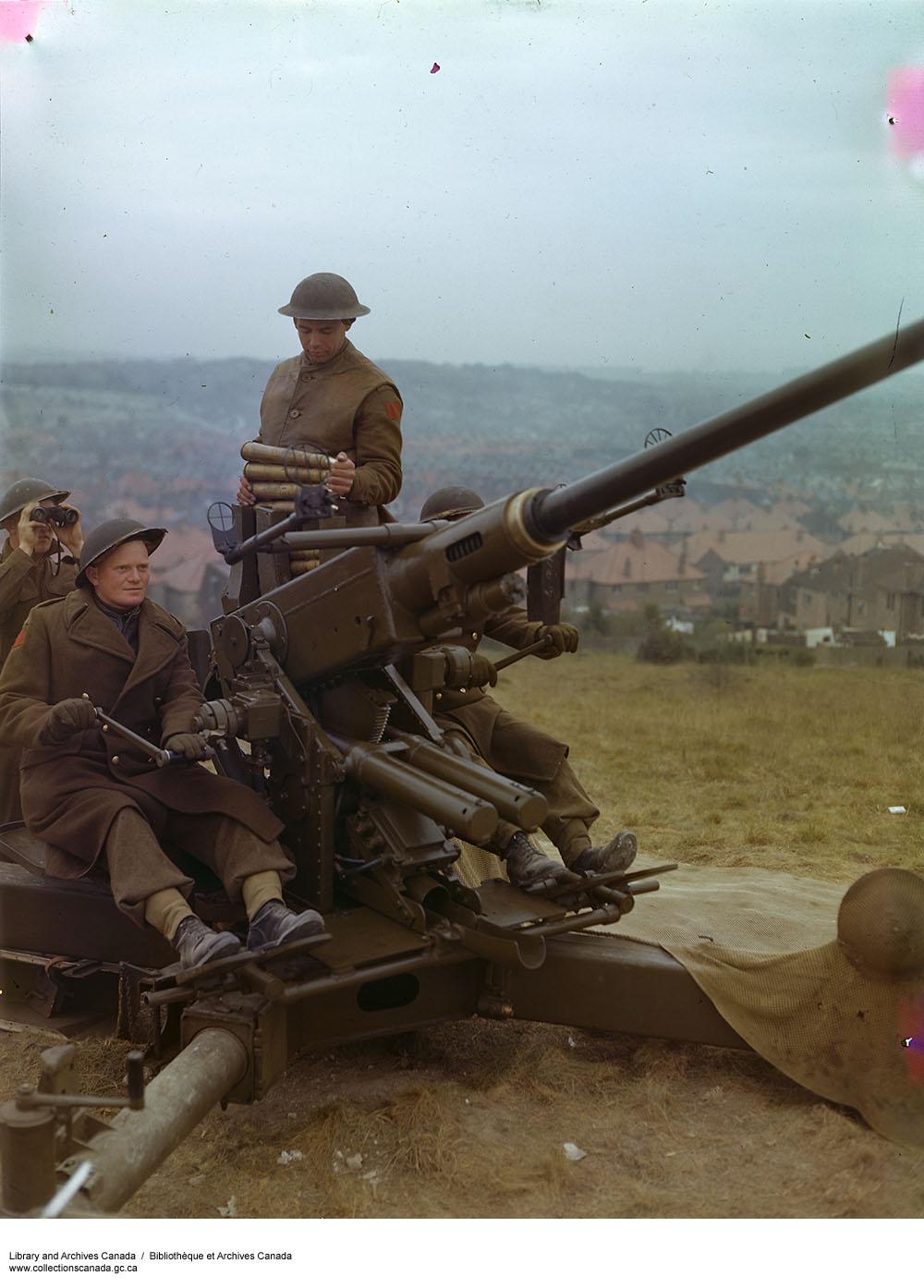
Photo: 1st Canadian Division (Anti-Aircraft in England), ca. 1943-1965.
© Government of Canada. Reproduced with the permission of Library and Archives Canada (2016).
Source: Library and Archives Canada/Department of National Defence fonds/e010750845
The first one shows a 40mm Bofors anti-aircraft gun on a hillside overlooking some houses.
It's obviously a posed shot, but it's the colour that really stood out and got my attention. It was a refreshing change to a historian who is used to seeing WW2 in black and white.
Click the image to see the full-size version.
A few clicks later I found another photo from the same sequence. It was seeing this photo that increased my interest due to more of the background scenery being in shot, as this opened up a greater chance of being able to identify the location.
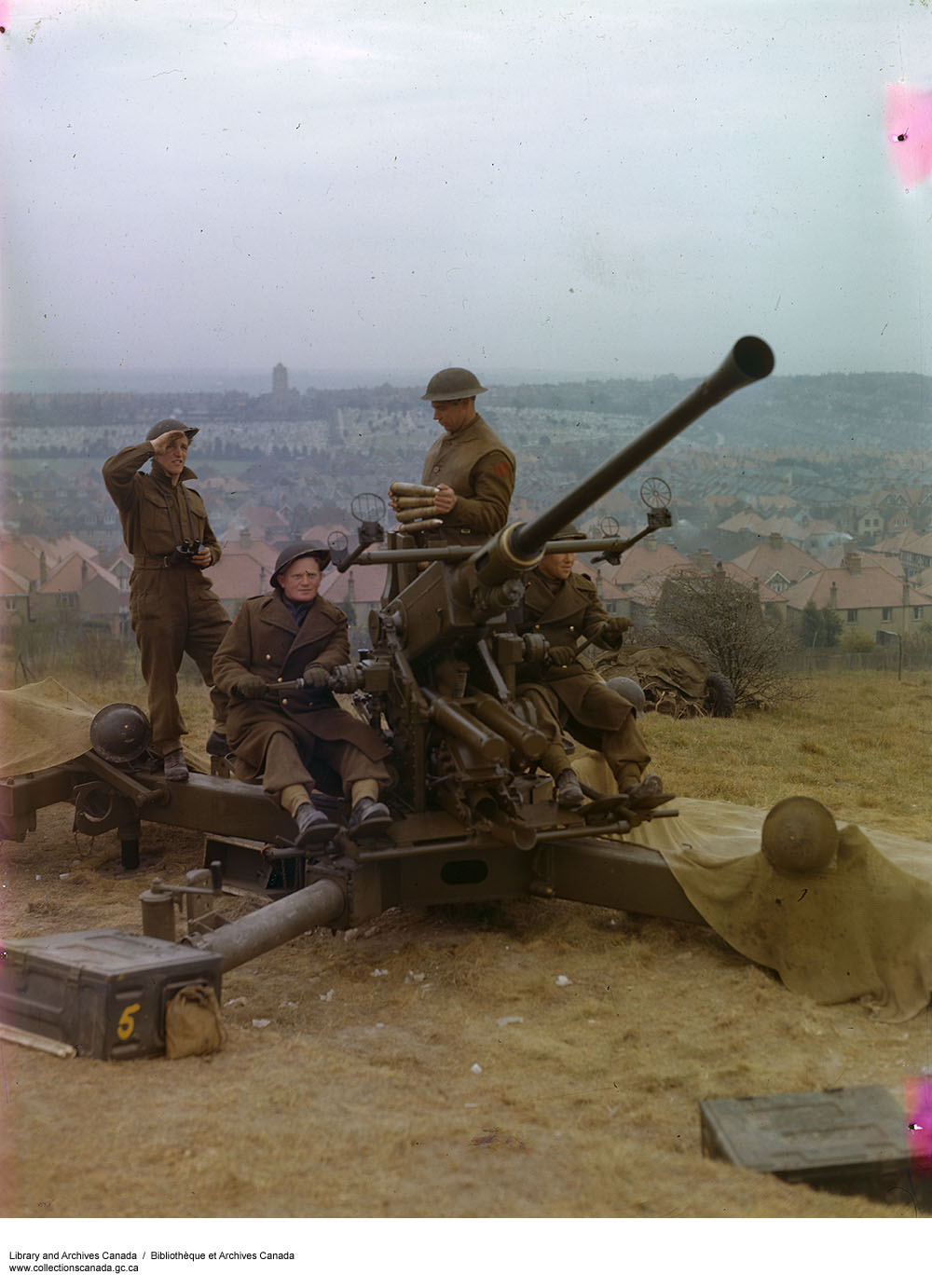
Photo: 1st Canadian Division (Anti-Aircraft in England), ca. 1943-1965.
© Government of Canada. Reproduced with the permission of Library and Archives Canada (2016).
Source: Library and Archives Canada/Department of National Defence fonds/e010750844
This wider view reveals a lot of interesting detail of the gun and its crew. Camouflage netting has been draped over the outrigger legs of the gun; helmets have been hung on the elevation gear handles. A pair of ammunition boxes are to hand.
To the right of the gun, by the bush in the background, can be seen the gun's road wheel assembly with a tarp draped over for camouflage.
Finding out more
The caption to both photographs was not very detailed: "1st Canadian Division (Anti-Aircraft in England), ca. 1943-1965.", but it gave me a finger-hold; I was keen to establish whether or not this photo was taken in East Sussex.
The association with 1st Canadian Division was the most important clue. I turned to my Order of Battle (ORBAT) database and found that the division was stationed in East Sussex from August 1942 until April 1943.
I also found that 2 Canadian Light Anti-Aircraft (LAA) Regiment was attached to the division. Checking their war diary, I found that their HQ was in Eastbourne, with their guns defending that town as well as Bexhill and Hastings.
Eastbourne
If the caption (such as it was) was correct and we could take a date of about 1943, then we had a choice of three towns. However, Eastbourne was my favourite location from the start.
Scrutinising the background of the second photo yielded a key feature; a church tower with a large cemetery of white headstones. Knowing that Eastbourne was a possible location, I recognised this as Ocklynge Cemetery from my investigation of bomb damage there. This placed the gun on the Downs to the west of Eastbourne.
The next question was whether the gun was simply wheeled out to this location for a one-off propaganda photo shoot or was an actual established gun position. I then searched my Concrete Evidence database for sites around this location.
I was in luck, as I had previously entered the contents of an anti-aircraft location statement into the database and, lo and behold, one 40mm Bofors gun was listed on this remote hillside. It was listed as position No.8 and we know from the document date that it was there at least from May 1943. However, the grid reference didn't convince me as being very accurate, which is not unusual.
I looked very closely at the photo background again and tried to work out a more precise location by looking at the position of the houses. I tried relating the photo to the street layout in Google Earth, but didn't really get anywhere.
First site visit
I then attempted a site visit on the off-chance that the grid reference might just get me to the desired spot. Sadly, the site visit hit me with the realisation that what was a open grassy slope in 1943 was today a dense area of woodland in which the houses and other reference points in the photo were not visible.
Tail between legs, I went back to the photo and tried a different method of getting an accurate location. Studying the houses again, I drew a series of three lines on the photo that lined up identifiable chimney stacks and roof angles back to the photographer's position.
I then translated these into Google Earth as shown below and found that the three lines pretty much converged within a 3 metre area (blue spot) about 70m away from the grid reference (yellow 'X').

Second site visit
Armed with this new information, I went back for a second visit. I had my revised site saved on my mobile as a map. This allowed me to see my current location in relation to the possible site I was looking for. I could therefore walk towards the spot seeing my progress updated in real time until I was on target.
I've reproduced the photo here; look at the two ammunition boxes.
Note how the lower left corner of the box on the right appears to be obscured by the ground level. The box is seemingly on the same ground level as the gun, but the box on the left is on a higher level.
Something that had bothered me on the first visit was that I could not locate such a sudden change in ground level in the area I had searched. Now, on the second visit with my phone telling me I was on my predicted gun location, I found that there was a step in the landscape, albeit thickly covered with ivy and brambles.
This terrace may be related to allotment gardens that are marked here on the map prewar. It seems odd, however, that the wartime photo doesn't show 'dig for victory' gardens being maintained here.
I then checked my phone and GPS receiver - the distance and bearing to the church tower at Ocklynge matched more or less and I was satisfied that I was pretty much at the location of the Bofors gun.

I can't claim 100% accuracy in my techniques, but I did find a spot with the terraced feature in the landscape. Due to the vegetation, I couldn't establish how long this feature is, but at least we now have a north-south line along which the gun was sited.
I did take a comparison photo (right) for what it's worth. It felt odd thinking that this was the same view 73 years on.
A better appreciation can be gained from the photo below. This was taken about 200m up the slope to the west in order to see over the post-war tree growth.

What does this tell us?
I started out with an archive photograph; although the caption was not great it was enough to get me a toe-hold into the landscape. Add the documentary evidence and we have the individual unit and a grid reference for at least May 1943. We now have a more accurate date than the captioned gives (c1943-65) and the precise location in the landscape.
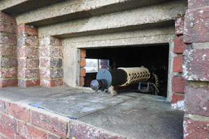
We also now know that a Bofors gun site such as the one in the photo does not appear to have supporting earthworks (such as slit trenches) or an emplacement. This will inform my future fieldwork. Such locations were often temporary; in October 1942 the Canadians devised the Duckshooting scheme whereby a site would be occupied for 48 hours. Once a gun had engaged an enemy tip and run raider, it was moved to another predetermined site to avoid Luftwaffe pilots from learning gun locations and thereby avoiding them in future.
Although this site was not a Duckshooter, it almost certainly would have seen action at some point. I've not yet located any action reports to confirm this though, but I'll update this page if I do find something.
The key thing for me is that my methodology - fieldwork guided by documentary research - works!
What other archive photographs are out there waiting to be identified?
- Pete

Email:
Blog Latest
Bishopstone reveals its pillbox secrets
18 October 2021
Pillbox or Observation Post?
10 June 2020
Uncovering the hidden secrets of a pillbox
8 June 2019
Review of 2018
31 December 2018

Wartime Christmas in East Sussex (2)
24 December 2018
Jargon-buster
Slit trench
Small, narrow trench designed to provide protection against shrapnel and other battlefield hazards. Technically distinct from a weapon pit (which was intended soley as a defensive position) slit trenches were also used as defence works.
War diary
A record of events kept by all units from the point of mobilisation. A diary's contents vary enormously from unit to unit; some give detailed entries by the hour on a daily basis while others merely summarise events on a weekly/monthly basis.
This site is copyright © Peter Hibbs 2006 - 2026. All rights reserved.
Hibbs, Peter Identifying a Bofors gun (2026) Available at: http://www.pillbox.org.uk/blog/245134/ Accessed: 15 July 2026
The information on this website is intended solely to describe the ongoing research activity of The Defence of East Sussex Project; it is not comprehensive or properly presented. It is therefore NOT suitable as a basis for producing derivative works or surveys!